Energy Production
LNG Construction
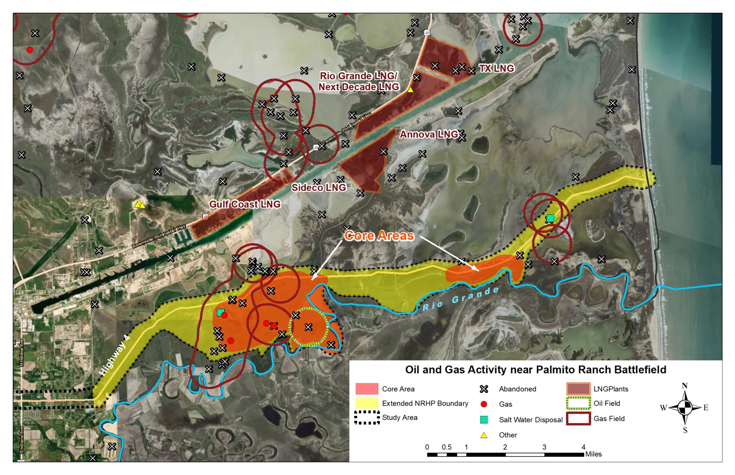
In addition to the city-scale development described in the previous section, large-scale commercial utility projects are a serious threat to the battlefield preservation. One such project includes the construction and operation of a liquified natural gas (LNG) facility planned on a total of approximately 2,000 acres primarily along the land between the north side of the Boca Chica Boulevard and the southern bank of the Brownsville Ship Channel. The facilities would include six liquefaction plants, four 180,000 cubic meter storage tanks, multiple storage and refrigeration units, compressor stations, and marine and truck loading facilities (Luck, 2019). The three terminals will be used to liquify and export 1.5 billion cubic feet of gas per day (Banktrack, 2018). Although the proposed LNG locations are not physically within the Palmito Ranch Battlefield site, the distance from the nearest LNG site is within a one-mile radius and most LNG sites are no further than a 2-mile straight-line distance. The proposed LNG facilities are surrounded by preserved lands, including the Laguna Atascosa National Wildlife Refuge (NWR) Bahia Grande Unit, the Lower Rio Grande Valley NWR, and the South Bay Texas Coastal Preserve. Specifically, three LNG terminals are proposed on land neighboring the Lower Rio Grande Valley Wildlife Refuge. The Annova LNG Brownsville Project’s proposed location is directly across the ship channel, while the Texas LNG Project is positioned toward Port Isabel. The Gulf Coast LNG is to be located less than 0.5 miles from the Highway 48 boat launch. The Rio Grande LNG Project and Rio Bravo Pipeline Project are the closest ones to Palmito Ranch. A 137 mile-long, underground gas pipeline consisting of twin parallel, 42 inch pipes will convey about 4.5 billion cubic feet of natural gas (LNG) per day from the outside of Kingsville to this area for distribution. The plausible activities involved in this processing and building gas production, liquefaction, storage, and export facilities will likely disturb the original landscape scene, onsite historical resources, and natural function of the battlefield landscape.
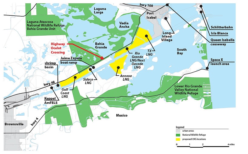
Potential impacts to the USFWS leased refuge area were previously discussed among local NPOs and stakeholders. Primary concerns identified include potential loss of critical wetland and rare loma habitat, which is important for a number of species including the endangered ocelot. It is feared that the three LNG terminals together would permanently cut off a critical wildlife corridor needed for the survival of the endangered ocelot and jaguar. Besides this, issues like surface and underground water pollution due to accidental natural gas leaks, spills, and accidents at the LNG facilities, soil degradation, viewshed and landscape aesthetics degradation, disruption of prescribed fire management on grasslands (important for maintaining prairie landscape and species relying on the grass habitat), and air, light, and sound pollution have the potential to threaten physical landscapes, fragile ecosystems, lives of species, and humans.
The Federal Energy Regulatory Commission (FERC), together with the Department of Energy (DOE) as a cooperating agency, conducted an Environmental Impact Assessment (EIA) as part of a mandated environmental review process that examined potential negative environmental impacts of the development. At the present time, the final approval for LNG construction has not been made. However, the presence of these LNG facilities in such close proximity to Palmito Ranch and the construction of the pipeline route endangers the quality and integrity of the historic landscape.
Oil and Natural Gas
Growing populations in the area mean increased demands for water and energy. Government ownership of land in the Lower Rio Grande Valley NWR does not negate the fact that in many cases, private parties own subsurface mineral rights which brings with it the legal right to explore for and extract oil and gas. The Lower Rio Grande Valley NWR has 172 oil and gas wells in total, the fifth highest number of all 560 refuges in the U.S., and includes:
- Oil – 4 active and 19 inactive
- Gas – 60 active and 79 inactive
- Oil and gas combined – 2 active and 8 inactive
The Lower Rio Grande Valley NWR is also ranked third in the number of injection wells with five active, four inactive, and one plugged (Leslie, 2016). There are numerous wells, both active and inactive, located inside the battlefield boundary and within the core areas. Impacts related to the presence of these wells include potential spills from brine, oil, and other hydrocarbons, disturbance of habitat, visual disruptions, noxious or foul odors, and construction activity associated with the exploration and development of wells and pipelines. As with the LNG facilities, the presence of these wells inside and in close proximity to the Battlefield endangers the quality and integrity of the historic landscape and its ability to continue to maintain its Civil War-era appearance.