Overview of Preservation Efforts
Most of the preservation efforts were funded by a grant (2017-2020) from the National Park Service American Battlefield Protection Plan (ABPP), a program of the National Park Service.
Despite some existing and potential threats, the battlefield today greatly resembles its 1865-era landscape as maintained by the combination of a salt prairie landscape, small family ranches held for generations, and the protective services of the U.S. Fish and Wildlife Service (USFWS) (McWhorter, 2010). However, for reasons not entirely clear, Palmito Ranch has disappeared from many historical narratives (Ginn & McWhorter, 2018). The site was designated a National Historic Landmark (NHL) in 1997 with archeological survey reports produced in 1999, 2001, and 2003.
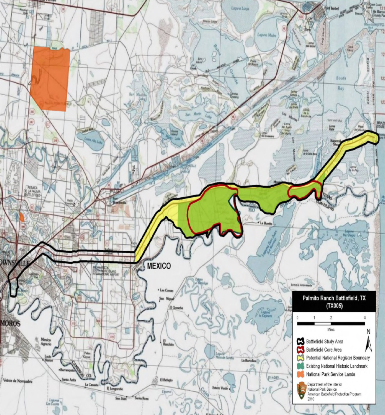
Palmito Ranch Battlefield was designated a National Historic Landmark (NHL) in 1997. It is a rare example of an extant site that has remained virtually unaltered since the time of the Civil War-era. Its pristine condition—despite the presence of some existing and potential threats—is due in large part to the combination of a salt prairie landscape, small family ranches held for generations, and the protective services of the U.S. Fish and Wildlife Service (USFWS). The battlefield Core Area is 3,744.78 acres including Palmito Hill, the site’s most iconic landmark, and the total size of the NHL area was extended to 9,391 acres in 2015.
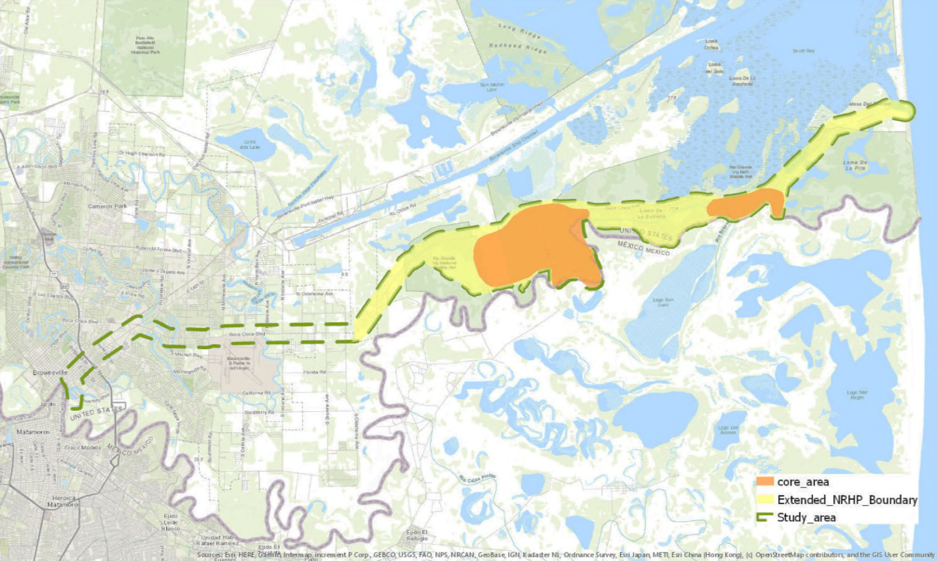
The 2015 ABPP grant lists the geographic coordinates spanning the extent of the extended NRHP area as 25°54´41"N and 97°22´28"W at the southwestern corner and 25°59´15"N and 97°08´56"W to the far northeast. It is an approximate 15-mile-long stretch from the west end where Boca Chica Boulevard meets the Brownsville city boundary and to the east, to the Gulf of Mexico coastline. The longest north-south distance is about a 2-mile area bounded by State Highway 4 and stretching south to the Rio Grande. Development has been restricted within the current NRHP boundary due to federal wildlife refuge holdings.
The Palmito Ranch Battlefield boundary was identified in 1993 on the National Register of Historic Places (NRHP), including the Battlefield Core Area (delineated in orange in the map below) referring to the portion of land where forces were engaged. The size of the Core Area is 3,744.78 acres including Palmito Hill, the site’s most iconic landmark, and the total size of the National Historic Landmark (NHL) area was extended to 9,391 acres (delineated in yellow in the map below) in 2015.
According to the CWSAC report, the Study Area represents the historical extent of the battle as it unfolded across the landscape and contains resources known to relate to or contribute to the battle event. The Core Area represents the areas of direct engagement on the battlefield where fire was delivered, received or connected. The potential national registered boundary that represented ABPP’s assessment of the Study Area’s surviving landscape and features, and representative of site integrity, was approved as the extended NRHP boundary by the 2015 ABPP grant led by Dr. Sohyun Park from Texas Tech University (now University of Connecticut).
The battle at Palmito Ranch occupies a unique place in American history as the last land battle of the Civil War. As part of the preservation efforts, the core part of the Palmito Ranch Battlefield was listed to the National Register of Historic Places (NRHP) in 1993, elevated to National Historic Landmark (NHL) status in 1997, and then extended to the official name of the Palmito Ranch Battlefield (TX005) as specified in the CWSAC Priority II. The ABPP noted in its 2010 report that more than 77 percent of the battlefield’s Study Area retained its historic integrity and its landscape continues to reflect its association with the historic battle. In contrast, Texas battlefields at Galveston I, Galveston II, Sabine Pass I, and Sabine Pass II (like so many others) have been deemed as no longer retaining enough integrity to merit listing as battlefield landscapes (American Battlefield Protection Program, 2010). The loss of these historic landmarks, along with the previously described losses to Fort Brown, again highlight the distinct historic significance of the Palmito Ranch Battlefield.
More Links for Preservation Efforts